Our Experience
with
Hurricane Katrina
Background. In January 2005 we moved from Bristol, Tennessee, to Bay Saint Louis, Mississippi. I April 2005 we purchased a lot in Waveland, MS and, in August, started construction on a house. We were living in an apartment in Bay Saint Louis, building the house in Waveland, and most of our belongings were stored in a commercial storage facility in Pass Christian, MS. (Follow this link for the story of our home construction.) On 29 August 2005, the Mississippi Gulf Coast was hit by Hurricane Katrina, a Category 5 hurricane with 165 MPH winds and a storm surge that ranged from 20 to 35 feet high. Most of the Mississippi Gulf Coast was destroyed; not damaged, not devastated, but destroyed. Consider this:
-
The town of Waveland, where we were building, simply no longer exists. From the beach inland 1/2 mile there is not a single structure standing, everything was washed away by the storm surge. Anything still standing in the town was gutted by the flood.
-
The town of Pass Christian had approximately 8,000 homes. After the hurricane, approximately 500 were still standing, most of those will be bulldozed because they were under 20 feet of water and are uninhabitable.
To better understand what happened to us, let's start with a map of the area, a review of how the winds blow around the eye of a hurricane, and the elevation of the Gulf Coast.
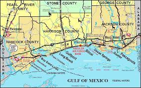
Map
This is the Mississippi Gulf Coast. The black arrow is Katrina's track -- on 29 August 2005 the eye of the hurricane passed directly through Hancock County, Mississippi.
![]()
![]()
![]()


Hurricane winds
Remember that the wind circulation around a hurricane is COUNTERCLOCKWISE. Follow the track of the storm (black arrow) and you will see that the wind blew directly off the Gulf of Mexico onto the Gulf Coast (red arrows) -- this is why the storm was so destructive -- the winds came unobstructed off the water, driving a wall of water 20 - 35 feet high, moving at almost 100 MPH. Imagine a bulldozer with a blade 35 miles wide, 20 - 35 feet high, moving at 100 MPH. That's what hit the Gulf Coast. Also, this counterclockwise motion is one of the reasons New Orleans was flooded so badly. Get a map of New Orleans and you will see Lake Ponchatrain lying north of the city. Because Katrina passed east of NO, the winds blew into NO from the North, off Ponchatrain into the city, driving water from the lake into New Orleans.
Low-lying land
Another factor contributing to the destruction is the elevation of the Gulf Coast, or, rather, the lack of elevation. Bay Saint Louis is one of the highest areas between Pensacola, FL, and Galveston, TX -- and the Bay (as it is called locally) is between 20 and 30 feet above Mean Sea Level (MSL). Old town Bay Saint Louis is (was, before Katrina) arrayed along Beach Boulevard, on top of a 20-30 foot high bluff.
As you move south from Bay Saint Louis to Waveland, Lakeshore, and Bayside Park, the elevation drops to only a few feet above MSL. Areas below Waveland are actually marshland with a few high spots that rise 2-6 feet above the marsh -- where people have built houses. I was building a house on Whispering Pines Drive in Waveland. My lot was 1,000 feet back from the beach and was surveyed at 15.7 feet above MSL -- and mine was considered a high lot.
Thus, when a 35 foot high wall of water was driven off the Gulf, Bay Saint Louis was flooded with water in buildings from 4 to 20 feet deep, depending on where in the Bay the building was located. Our apartment was 1/2 block off the beach at one of the highest points; we have 4-5 feet of water in the apartment. In Lakeshore, the water was 35 feet deep.
Our experience
We heeded the hurricane warnings and evacuated on Sunday, 28 August. Along with family members, we took a convoy of four cars to Laurel, MS. We did not realize it, but the storm tracked directly north, passing over Laurel, still at hurricane strength. We spent Sunday and Monday nights (28 and 29 August) in a hunting lodge in the pine woods north of Laurel. Hurricanes spawn tornadoes and the place we were staying was hit by 4 - 6 tornadoes -- several trees fell onto the lodge, trees blocked all roads and highways, power was out, as were phones.
On Tuesday, I located a chain saw and cut the trees that were blocking the driveway. We had to leave the lodge because we had no electricity and no water. And, because the lodge was located in a deep rural area, we knew we would be one of the last areas to be restored. We struck out driving to our relatives' home below Donaldsonville, LA. We did not realize until we got well underway just how extensive the destruction was. As you read this, get out a road map of Mississippi -- draw a line through Jackson, MS, running east and west across the state. Below that line, for weeks after the hurricane, there was NO electricity and NO phone service (Remember, cell phones depend on landlines to operate, thus, my cell phone would show strong signal, but could not connect because the phone network was destroyed.). As we drove toward Louisiana, we began to realize there was nothing operating -- without electricity, everything was shut down -- restaurants, shops, stores, traffic lights, and gas pumps. We finally arrived at our relatives' homes with four cars running on fumes and six very hungry, tired people.
On Wednesday, 31 August, Rose and I drove from Donaldsonville, LA, to Bay Saint Louis. East of Donaldsonville, LA, there was no electricity, no gas, nothing open, trees down -- and as we went west the intensity of destruction increased. We arrived at in Bay Saint Louis to find:
-
No gas, no electricity, no water, nothing but destruction.
-
Bay Saint Louis and the surrounding area for mile upon mile was a scene of total destruction -- houses smashed by the storm surge, debris piled solid for miles, trees snapped off or uprooted, cars tossed around and piled randomly around, boats in the tops of trees, dead animals, and everything covered with a layer of mud.
-
Some streets were partially open where local people had driven bulldozers down streets to get them somewhat open.
-
Our apartment had been flooded and was now covered with mud, six inches deep.
-
Our 1989 Nissan pickup had been submerged and was ruined.
On Thursday, 1 September, my cousin's son, his friend, and I went back with a 16-foot trailer. We retrieved from the apartment some wooden furniture -- three tables, six chairs, top of a cupboard. On Friday, 2 September, we went back with the trailer and took out the grandfather clock and all the dishes. Everything else in the apartment was lost:
-
Clothing was wet and molded.
-
Shoes were covered with mud and molded.
-
Stainless steel and iron cookware was pitted and corroded from being submerged in salt water.
-
Anything electrical was ruined, inoperative.
-
Food was ruined, except for canned food, which we donated to people who had stayed behind and who were now running out of food.
-
In the bedrooms, the chests of drawers holding our clothes had been submerged and were now waterlogged. Drawers were impossible to open, the wood had swelled and was now splitting, and mold was growing everywhere.
-
Anything made of paper or cloth was ruined -- completely wet, now covered with fast-growing mold or mud -- including books, financial records, legal records, and the like.
When we evacuated, we thought we would be back in the apartment and back to normal, thus, we took with us only a couple of changes of clothes, one extra pair of shoes, and a book to read. In the following weeks while living in Louisiana, we managed to:
-
Buy a few more clothes.
-
File insurance claim.
-
Start an inventory of our loss.
Two weeks later, on 16 September, the town of Pass Christian was opened and we were able to get to our storage unit. The unit had been under 20 feet of water and everything inside was ruined from submersion, mud, and from sitting in the heat wet and muddy for three weeks. In the storage unit we lost:
-
Rose is a quilter; she had accumulated a lifetime of antique quilts, she had several quilts she had made, and she had a vast collection of fabric for quilts. All of this was destroyed -- quilts, all her quilting tools, all quilting fabric.
-
All our family photo albums.
-
Washer and dryer.
-
Artwork -- framed paintings and prints.
-
Books -- 18 cartons of books, much of our personal library.
-
Tools -- big Sears Craftsman roll-around tool chest full of tools; power tools; gasoline leaf blower and weed eater.
-
8-inch reflector telescope and all accessories.
-
Secretary desk that had been custom made for us in Taiwan in the late 1970's.
-
Material to be used in our new house -- two water heaters, sinks, faucets, nine ceiling fans, electrical fixtures.
Final outcome
As of mid-October, we had moved back to East Tennessee and are living in an apartment in Knoxville, a few blocks from my parents. Our insurance company (United Services Automobile Association) paid off quickly -- we got book value on the 16-year-old truck and we got the full value of our policy limit for personal possessions. We are now replacing a few of the lost items and trying to decide what to do next.
The photos
Here are links to photographs that we took of the wreckage left by Hurricane Katrina.
-
Our apartment.
-
Here we are salvaging what we can.
-
House we were building.
-
Bay Saint Louis, Mississippi
-
Photos of general destruction.
-
Aerial photos of Bay Saint Louis and Waveland.
-
Aerial photos from Pass Christian.
Aerial photos of the Mississippi Gulf Coast
Here is an excellent site -- it's filled with aerial photos of the Mississippi Gulf Coast. If you are from the Coast, you will likely recognize locations in these photos -- however -- if you are from the Coast and have not seen the totality of the destruction, be warned that it's not like you remember it. Go to this link: http://www.nicholas.duke.edu/psds/katrina.htm where you will find a map of highlighted areas. Click on a highlighted area to see aerial photos of that area.
Links to sites with photos and stories from Bay Saint Louis and Waveland
Many people from Bay Saint Louis and Waveland have posted their experiences and photos on various websites. Here are links to a few -- I'll add more as I find them.
-
http://www.femaforgotwaveland.com/photos.html When you go to this site, scroll to the bottom of the page and click on the link to "resident's stories" -- there you will find the story of one person who rode out the hurricane -- he was swept away and spent two days hanging onto a tree with bodies and debris all around.
-
http://www.midcarolinatraumarac.com/photopages/Pictures%20of%20Waveland,MS/
-
More to come -- check back later.